
Category Maps
| 开发者 | wpwoodo |
|---|---|
| 更新时间 | 2025年9月18日 17:23 |
| PHP版本: | 7.0 及以上 |
| WordPress版本: | 6.8 |
| 版权: | GPLv3 |
| 版权网址: | 版权信息 |
详情介绍:
Category Maps is a powerful and easy-to-use maps plugin that let's you create very nice and completely customizable maps based on any (custom) post type - fully compliant with legal data protection rules.
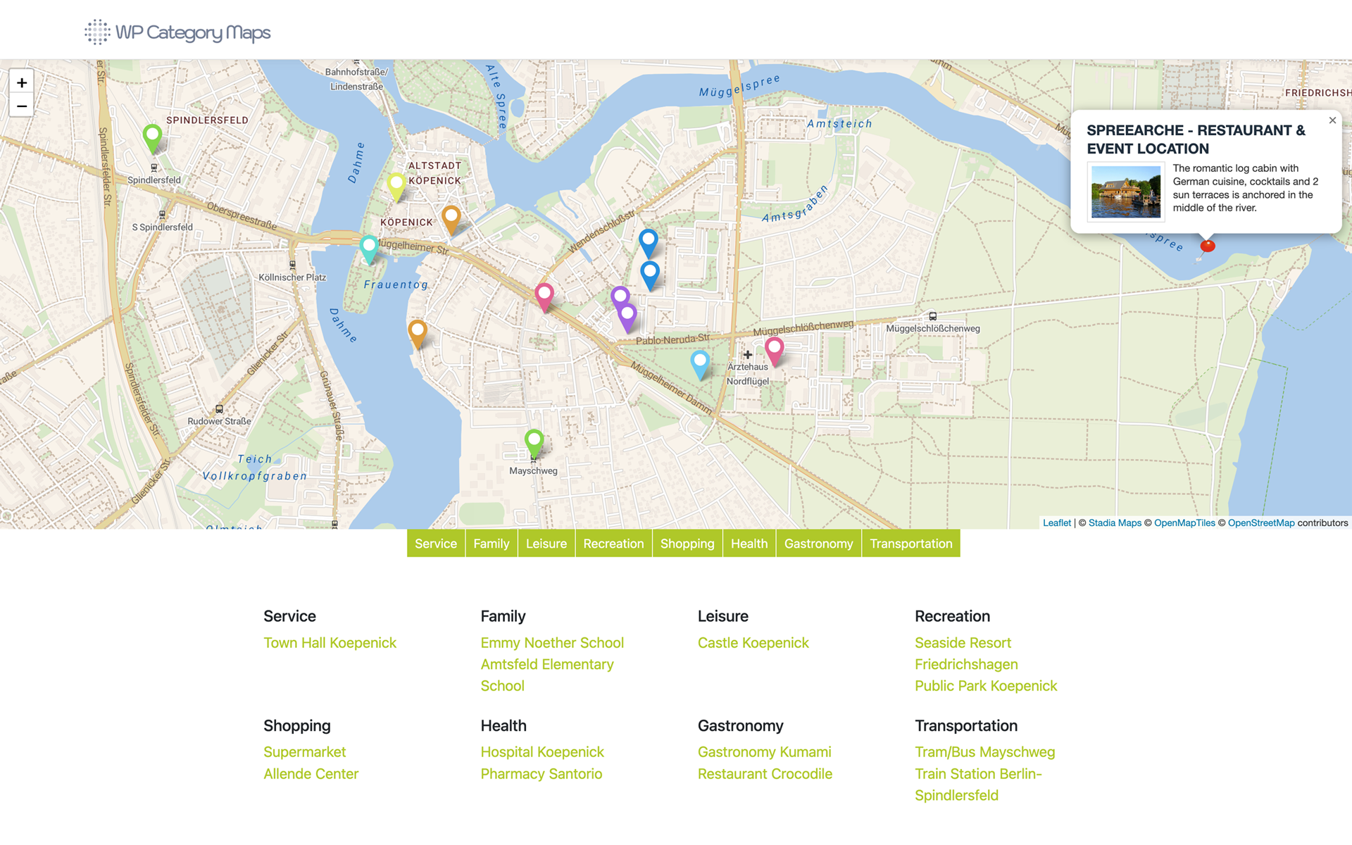
Create high quality category maps based on any (custom) post type that stores location data in its meta information. Location data can be added easily through the plugin. Just select a (custom) post type and the related taxonomy. The plugin will automatically create markers based on the location data of the related posts. Location data may consist of latitude / longitude pairs or addresses (depending on the post type definitions). An open source geocoder will resolve addresses or determine them from the given geo-coordinates.
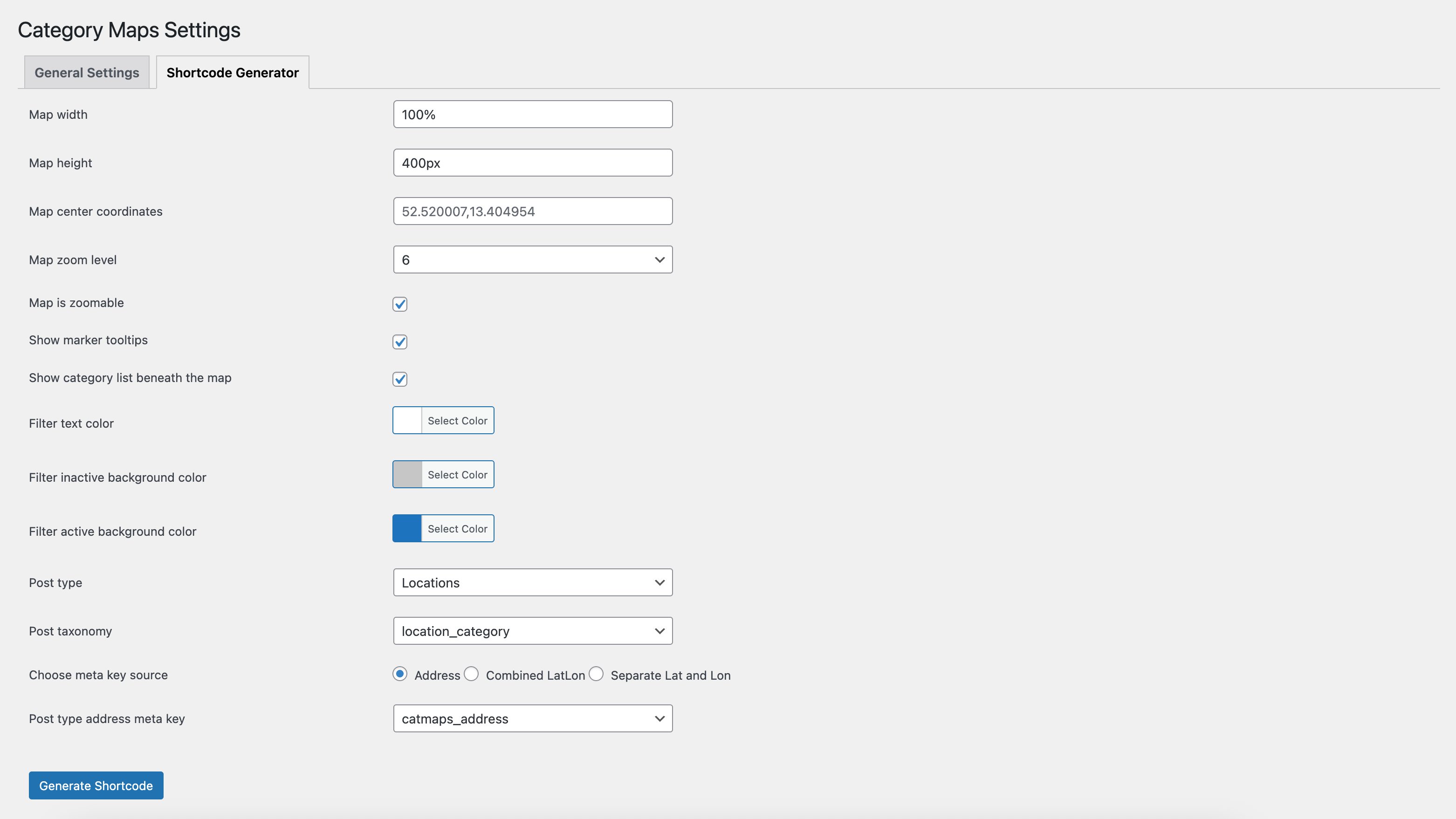
The integrated easy-to-use shortcode generator will help you to configure your maps settings. It lets you customize the appearance of the maps and decide if you want to have an additional category overview beneath the map.
Putting the resulting shortcode on any page or post will display a pretty nice category map to your site visitors. Allow your visitors to pick what they want to see by filtering markers based on their category.
Since this plugin works completely with OSM / leaflet no maps API key is needed. Furthermore, it's fully compliant with legal obligations for data protection - no personal data will be passed on.
Use Cases
- Local businesses: Show your branches with categories such as “Sales”, ‘Service’ or “Partners”.
- Travel blogs: Showcase travel destinations with filters for “Beaches”, ‘Museums’ or “Adventure”.
- E-commerce: Visualize delivery areas or pick-up stations for your customers.
- Powerful and easy-to-use maps plugin
- Completely customizable maps for your posts and pages
- Works with any (custom) post type that stores location data in its metas
- Location related meta data can easily be added through the plugin
- OpenSource geocoder included – no API key needed!
- Easy-to-use shortcode generator with a familiar interface
- Category list beneath the map (optional)
- Fully compliant with legal data protection rules
- Different map layers available (PRO)
- Add an individual map tile layer (PRO)
- Customizable category colors (PRO)
- Add category independent markers to your map (PRO)
安装:
Installing the plugin in your WordPress website
- Download the plugin.
- Then click on Upload plugin in the 'Plugins' menu and then start the installation by clicking on Install now.
- Activate the plugin by clicking on the link Activate this plugin.
- The configuration is done in the backend under the corresponding menu item.
- Download the plugin to the directory “/wp-content/plugins” (the zip file must be unzipped)
- Activate the plugin in the plugin menu of WordPress.
- The configuration is done in the backend under the corresponding menu item.
屏幕截图:
更新日志:
1.4.3
- Undefined variable $address fixed
- Trying to access array offset on value of type bool fixed
- Variables and options escaped when echo'd
- Generic function/class/define/namespace/option names changed
- Custom styles for map removed
- Bugfix
- Libraries updated
- Minor enhancements