
MapGeo - Interactive Geo Maps
| 开发者 |
carlosmoreirapt
pcarvalho freemius interactivegeomaps |
|---|---|
| 更新时间 | 2026年3月12日 06:15 |
| 捐献地址: | 去捐款 |
| PHP版本: | 7.0 及以上 |
| WordPress版本: | 6.9 |
| 版权: | GPLv2 or later |
| 版权网址: | 版权信息 |
标签
下载
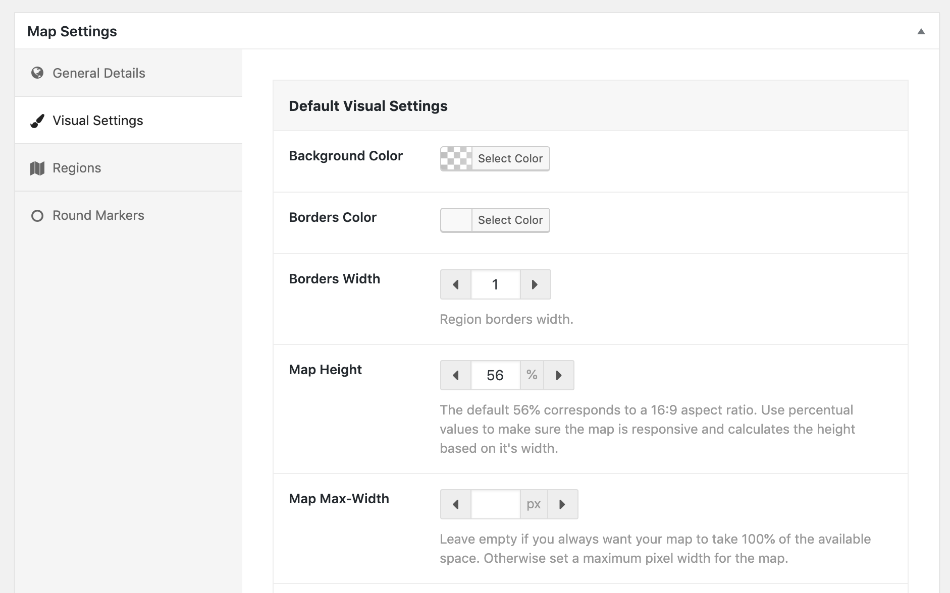
详情介绍:
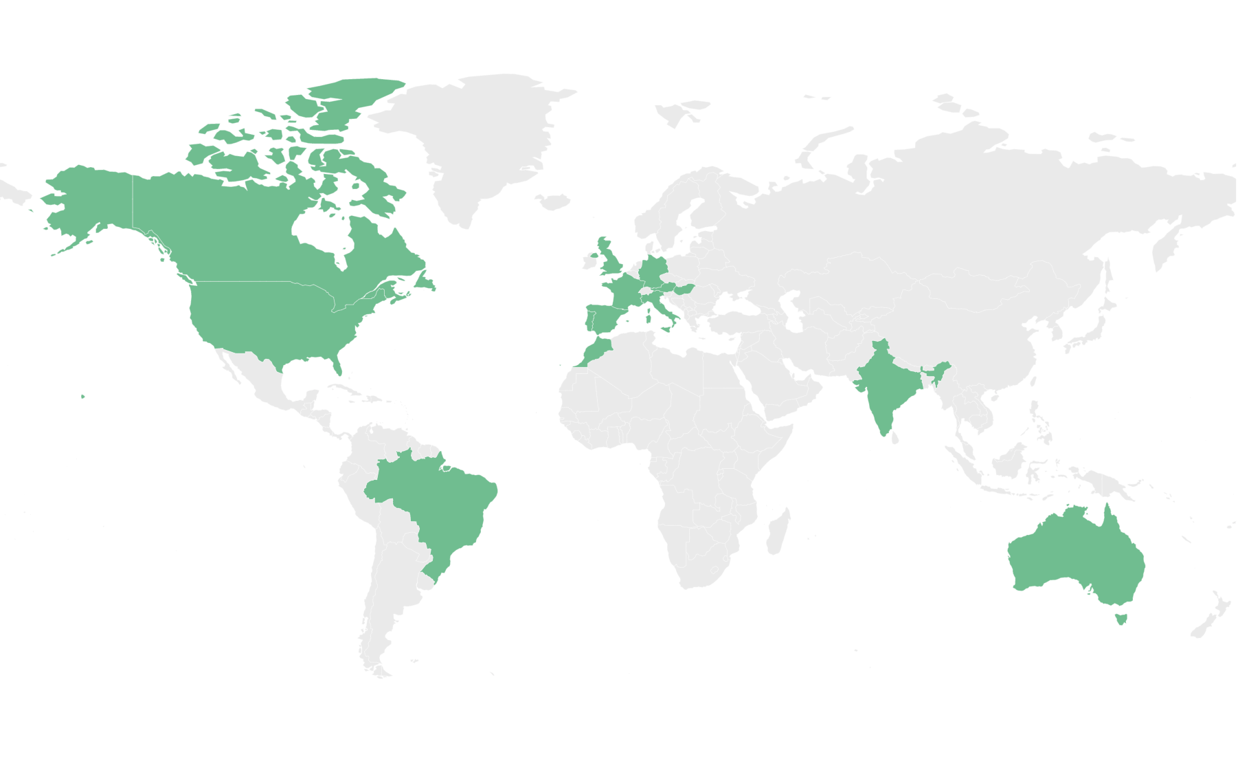
- World map (with and without Antarctica)
- World map divided by continents (different variations)
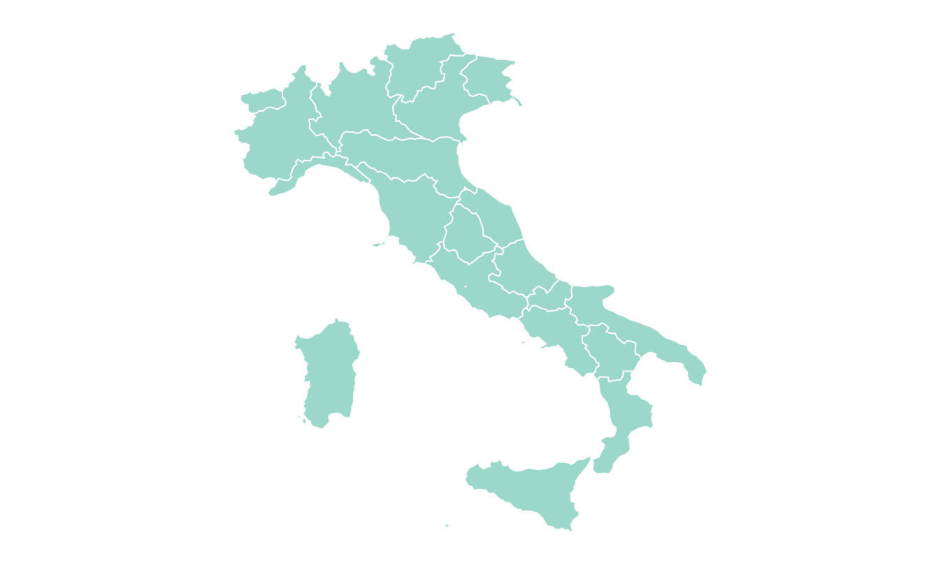
- Maps of continents and regions (Africa, Asia, Caribbean, Central America, Europe, Latin America, Middle East, North America, Oceania, South America )
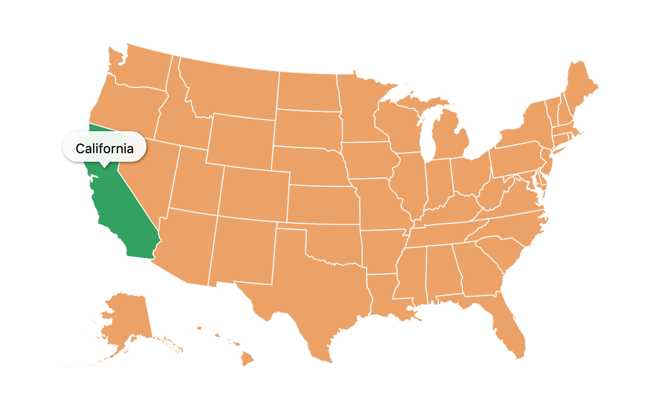
- US States divided by counties (California, Texas, Florida, New York and all the others)
- Mexico county maps
- Canada county maps
- Most countries in the world, including United States of America (USA), Germany, France, United Kingdom (UK), Netherlands, Spain, Australia, Italy, Poland, South Africa, Brazil, India, Japan and many others.
- Some countries with different map variations like France, divided by regions or departments, Portugal divided by districts or municipalities, among others. Create your first interactive map in minutes! Use it to display your visited countries map, travel map, office locations, projects map, representatives map, statistics map, data visualization map or any other thing!
- Create as many maps as you want
- Responsive and cross-device
- Color countries
- Add round coloured markers
- Set hover color change
- Set click actions, like open a new window
- Choose from different map projections (Mercator, Miller, NaturalEarth1, among others)
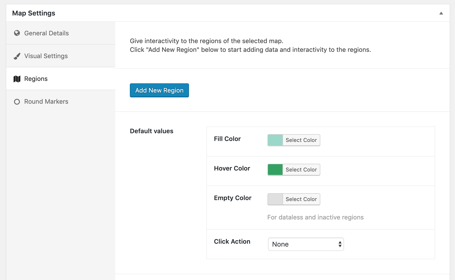
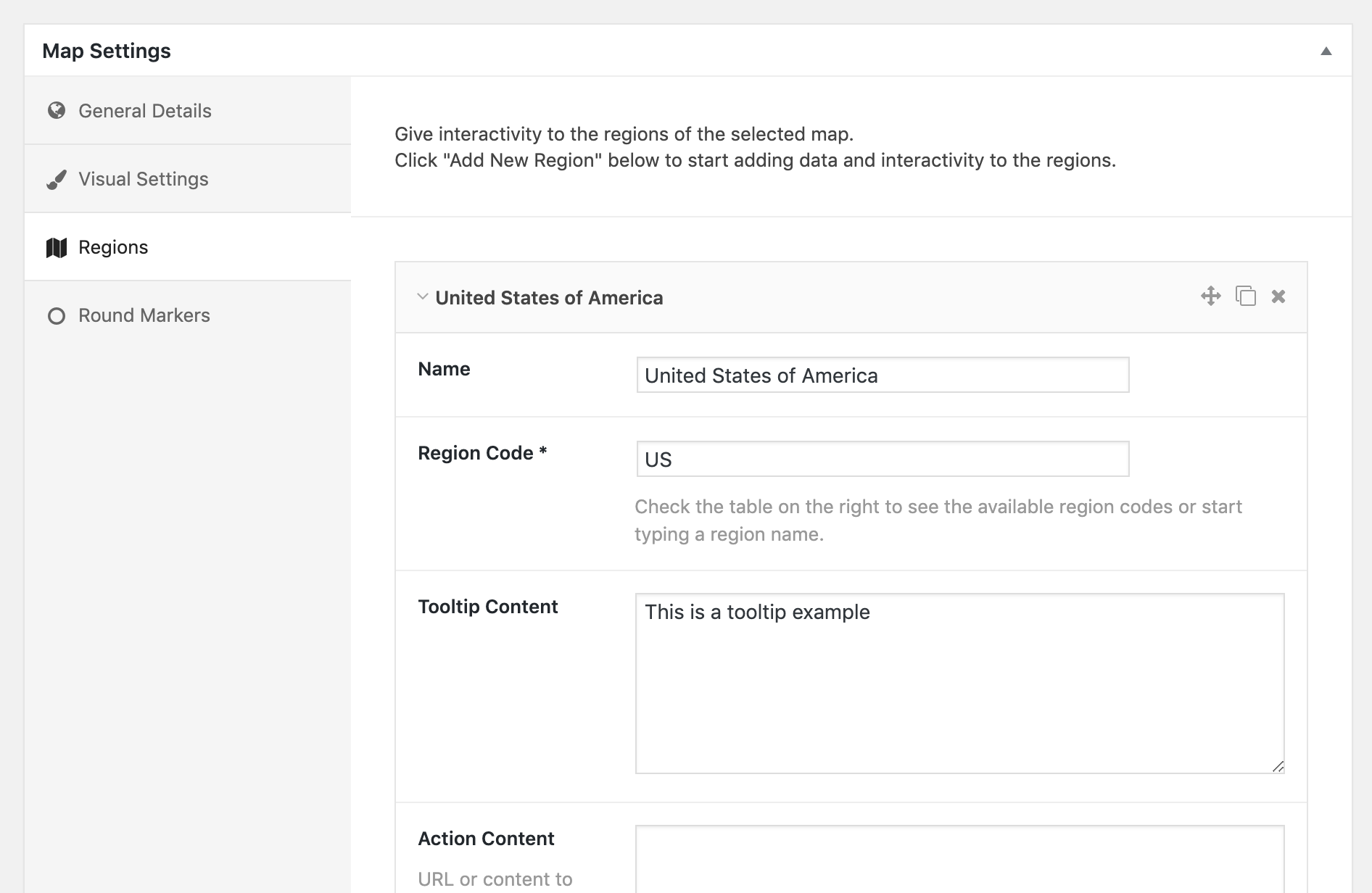
- Select which regions to display in a map
- Exclude specific regions from a map
- Display HTML tooltips on hover
- Zoom controls and Pan
- Colour regions and markers individually
- Change initial zoom and center
- Cluster markers
- Add Legend
- Custom images as markers
- Vector icons as markers
- Text Labels
- Display content on click outside the map
- Display content in a lightbox
- Group regions
- Create heatmaps (choropleth maps)
- Add lines connecting markers
- Overlay different maps (have US states map on world map for example)
- Populate map automatically from existing categories or Tags
- Advanced zoom options Features Examples | Go Pro
屏幕截图:


常见问题:
Do I need an amcharts account or license for the plugin to work?
No, you won't need any license or specific account. The plugin will work out of the box.
Do I need a Google Maps API Key for the plugin to work?
No, you won't need one. The plugin will not use the Google Maps API. However you can add a Google Maps API Key in the settings of the plugin to enable geocoding when adding markers and therefore get the latitude and longitude directly in the plugin's administration.
Where can I get coordinates for a marker?
You can get the latitude and longitude needed to a add a marker to a map using sites like GetLatLong or LatLong.net or any other similar website. Optionally, you can add a Google Maps API Key in the settings page of the plugin and this will enable you to get the coordinates directly in the map administration panel, when adding a maker. In this case, Google's geocoding service is only used in the administration to get the coordinates, it won't be used when the map displays in your pages.
Where can I learn how to use the plugin?
You can visit the documentation pages on the official website.
The map is not displaying when using WP Rocket!
You can visit this article on how to use the plugin together with WP Rocket.
更新日志:
- [Pro] Option to set base map to always display (when drilldown/filter is enabled)
- [Pro] Option to set self-hosted amcharts library
- [Pro] Multiple Bug Fixes
- New Maps: Afghanistan and India/Asia map version
- [Pro] Bug fix on actions triggered by external dropdown
- [Pro] Better options for "content on the right" visuals
- [Pro] UAE drilldown bug fix
- [Pro] Option to include count in external live filter for overlay maps
- New Maps: Jordan and USA States divided by congressional districts
- Workaround for WP-Rocket minification issue
- [Pro] Option to change marker and label sizes on smaller screens
- Option to disable live preview
- [Pro] Lightbox mobile issue fixed
- Add CSS class when loading
- Freemius WordPress SDK update
- [Pro] Lightbox height for iframe bug fix
- [Pro] Bug fix on overlay maps with repeated regions
- [Pro] HomeButton bug fix on Firefox
- [Pro] Option to set tooltips to display on click or be always visible
- [Pro] Tooltips from overlay maps will inherit rules from original maps
- [Pro] Option to set background colour of content container
- [Pro] Mobile size option for round markers and vector icons
- [Pro] Auto labels in regions option to read from custom source
- [Pro] Bug fix on overlay maps with grouped regions
- [Pro] Home button now resets also click action content
- [Pro] Placeholders can now be used in Action content
- [Pro] Dropdown option for Live Filter
- [Pro] External Dropdown search bug fix
- [Pro] Custom actions bug on overlay maps fixed
- [Pro] Actions fixed to accept cyrillic characters
- [Pro] External custom legend option
- Fixed shortcode issue on cloned maps
- Freemius WordPress SDK update
- [Pro] bug fix on live filter with grouped regions
- New Maps: Timor-Leste, Trinidad and Tobago, Falkland Islands, Guam, Northern Mariana, Montserrat, Grenada, Martinique, Saint Barthélemy, U.S. Virgin Islands, British Virgin Islands, Guadeloupe, Turks and Caicos Islands, Haiti.
- [Pro] improvements on the overlay code
- [Pro] external dropdown improvements when using overlay maps
- [Pro] Option to set action content of json source
- [Pro] Drilldown fix for Serbia
- Release Bump
- [Pro] Legend text color option
- Small change in maps model to allow filters to work better
- [Pro] Zoom on Click fix for South Africa in higher definition maps.
- [Pro] Option to disable hover color on heatmaps
- [Pro] Option to hold click action on mobile, to display tooltip
- [Pro] Click action to drilldown to specific map
- [Pro] Option to disable tooltips on mobile
- New maps: Iraq and India2020
- [Pro] Convert lat and lon to float when coming from JSON
- [Pro] Pass the action content through the_content filter
- [Pro] Prevent actions code to run on admin
- [Pro] Legend improvements (disable cutoff)
- Fix bug when URLs included "&" characters
- Limit pan behaviour
- [Pro] Zoom to clicked region improvements
- [Pro] Allow JSON for custom taxonomy query
- [Pro] Allow to use different source for label in external dropdown
- [Pro] zoom to cluster markers improvements
- [Pro] Auto Labels bug fix
- Saltus framework updates
- Code improvements to prevent conflicts
- [Pro] Marker actions bug fix
- [Pro] Drilldown bug fix
- Code Improvements - Saltus Framework update
- [Pro] Cluster Markers improvements
- Bug fix in admin screen
- [Pro] Heatmap ranges for markers
- [Pro] Marker clusters improvements
- New maps: Norway, Montenegro, Iran and South Sudan
- [Pro] Overlay bug fixed
- [Pro] Option to enable visual map (OpenStreetMaps) for coordinates fields
- Grouped Regions bug fix
- Asia map default zoom fix
- Bug fixes
- New setting options and reviewed labels
- Warning when click action is not selected
- [Pro] Legend bug fixed
- [Pro] JSON source improvements
- Elementor Widget added
- Better assets loading in admin
- Marker selection tap bug solved
- [Pro] Allow heatmap value reference to have dot notation
- Allow files to load async - beta
- [Pro] Custom taxonomy as map regions source
- Fixed bug causing bulk editing to be broken
- [Pro] overlay map options are not now sortable
- [Pro] trigger custom action on custom json data source bug fixed
- [Pro] allow styles when sanitizing action content
- [Pro] improve group hover behaviour on Select
- [Pro] extra options for JSON data source
- Added better javascript methods to maps manager object
- Improve sanitizing meta info on save
- [Pro] label position bug fixed
- New maps: UK Countries (consists of England, Scotland, Wales, North Ireland, with Ireland for shape consistency), World Timezones, British Indian Ocean Territory, Cayman Islands, Cocos (Keeling) Islands, Comoros.
- Update to amcharts v4.9.10
- [Pro] Option have external dropdown
- [Pro] Improved fullscreen behaviour
- [Pro] Option to have external/bigger zoom controls on mobile
- [Pro] Option to set custom tooltip Template for each series of data
- [Pro] Option load specific amcharts version and setup locale
- Live preview improvements
- [Pro] Touch devices options - drag grip and tap to activate
- [Pro] Bug fix on labels, preventing actions from running
- [Pro] Fullscreen feature improvements
- [Pro] Option to allow empty overlay
- [Pro] Button to expand the map full screen
- [Pro] Fix bug on display content actions
- [Pro] Callback function added
- Workaround New Zealand and Russia default projections offset
- New maps: Bahamas, Eritrea, Ethiopia, Gambia, Ghana, Guinea Bissau, Guyana, Kuwait, Laos, Libya, Luxembourg, Madagascar, Mozambique, Myanmar, Niger, North Macedonia, Rwanda, Sierra Leone, Suriname, Togo, Turkmenistan.
- [Pro] Option to display live filter of overlay maps
- [Pro] Labels improvements and bug fixes
- [Pro] Bug fix for click action not being triggered in some markers
- [Pro] Bug fix for Legend not highting markers
- [Pro] Option to add label below round markers and icon markers automatically
- [Pro] Active state color option for regions
- [Pro] Custom json as source for regions
- [Pro] Custom Legend Option
- [Pro] Labels bug fixed
- [Pro] Group regions fix
- [Pro] Marker Pro Actions bug fix
- Allow decimal values on border width option
- Translation improvements
- [Pro] Render shortcodes in tooltip
- New Maps for Cuba, Jamaica, Uruguay and Mexican county maps
- [Pro] Customize tooltip shadow options
- Improved compatibility with Elementor
- [Pro] Custom Action bug fixed
- Improved loading of assets to workaround cache
- Added Actions to help adding markers and regions
- Forced amcharts version to 4.8.0 (4.8.1 introduced a hover bug)
- Improved group hover
- Added new maps (Canada regions and other world maps)
- [Pro] Fix group hover bug
- [Pro] Improved Lightbox feature
- Fix conflict with Async Javascript plugin
- [Pro] Improved feature to drag auto Labels
- [Pro] Fixed bug when initial zoom was changed
- [Pro] Fixed bug with Albers projection
- [Pro] Better handling of Pro Actions
- Upgrade option introduced
- Remove drag/resize on mobile
- Freemius OptIn added
- Zoom in preview bug fix
- Map List Update
- Disable drag when zoom is disabled
- Gutenberg block bug fix (ccs class)
- Small code improvements
- Extra maps for Portugal added
- Tooltip improvements to handle images
- Preview bugs fixed
- Zoom Controls added (Settings > Map Features )
- Automatic line breaks in tooltips
- Option to enable rich editor for the tooltip (Settings > Editing )
- Gutenberg Block
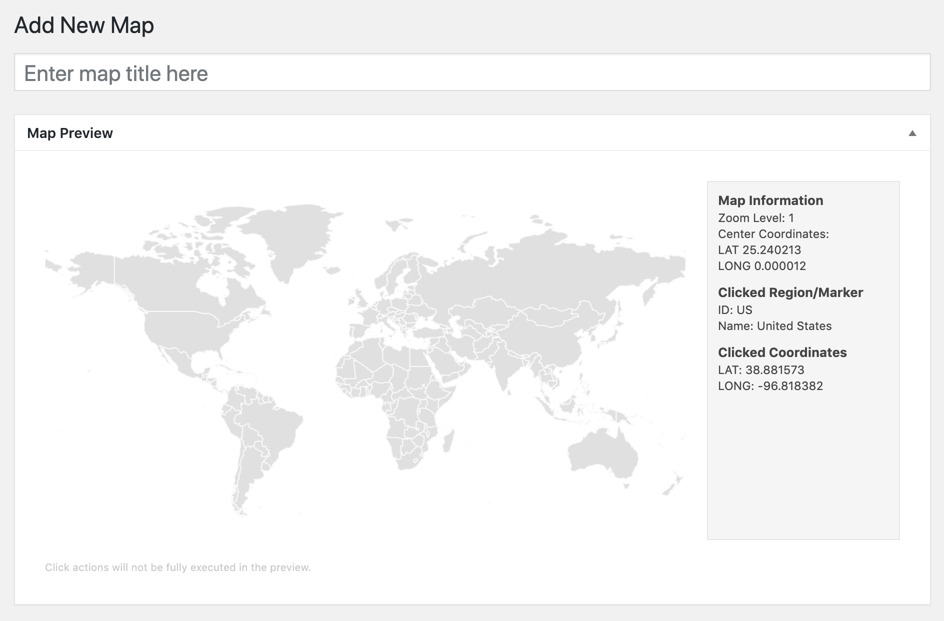
- Map Image Preview
- PHP 7 compatibility
- Initial Release